Buffer zones
 Swedish

Contents
A GIS-plugin (for RegWise and PlanWise) has been developed that can create buffer zones around for example water streams. You can also use polygon layers as they are for the overlay analysis. Several buffer layers may be used, in that case you set the Buffer width = 0. The tool then splits the stands into main stands and edge zones that intersect any of the buffer layers, and creates a modified stand register file and forest map shape-file that you can import as a new forest area. The tool is currently being tested and will be made available during 2016. To test it right away you can download it from the Heureka file repository:
Please note that after using the tool, you have import the created stand register file and shape file as a new analysis area,
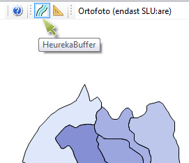
The tool is started by with the button called HeurekaBuffer:
Then a form is opened that has built-in help topics. Hover with the mouse over an item (label or input box) to show tooltips.
